Here you will find a free Moscow map in English (Moscow metro map, Moscow city centre map with main places to visit), very useful during your trip. We have found several plans and maps that can help you prepare for the trip or to use on the spot. Note that you can download these maps to your phone so that you can consult them in Russia, even without an internet connection.
Free Moscow city centre tourist map in English
This plan is published by the Tourism Committee of the City of Moscow. It only shows the city center but already allows you to quickly see where the main sites are located. Right in the center, you will recognize the Moscow Kremlin. On its right side, it is the Red Square with the Lenin mausoleum and at the end the St. Basil’s Cathedral. At the top right, you will see the stations of Leningrad, Yaroslav and Kazan. The first is to reach Saint Petersburg by train, the others are departures from the Trans-Siberian Railway. You can download this tourist map from the official website.

Moscow city center map with main places to visit
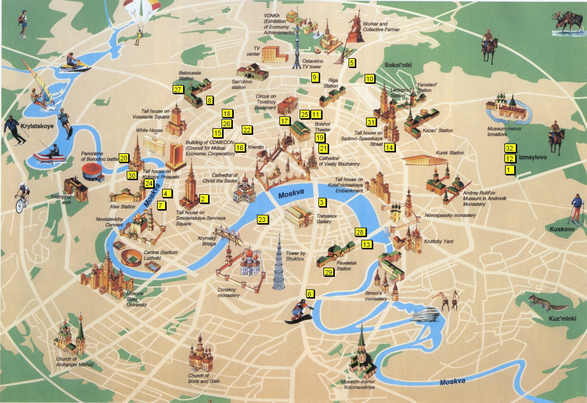
This Moscow map comes from an unidentified source on the Internet. It is repeated many times without mentioning the source. This plan makes it very easy to identify areas of interest in the city. On this subject, we have a dedicated blog post Top places to visit in Moscow.
Point 30 is the skyscraper of the Hotel Ukraine, the starting point for Radisson cruises. The imposing building complex at the bottom right is the University. At the very top, there is the famous statue “The worker and the collective farmer”, made for the Paris Universal Exhibition in 1937. Next to it is the fascinating museum-memorial of astronautics and the exhibition center ( VDNKh). On the right, bordered by a small canal, is the Izmaïlovo market and its Kremlin.

Moscow metro map
This map comes from the official website of the Moscow metro in January 2020. You can consult the interactive map here (in Russian). You can also download the Moscow metro map from the official website.
So, here are some metro stations to know:
- “Okhotny Riad” / ”Teatralnaya” / ”Ploshad Revolyutsii”: This is the closest station to Red Square, the Bolshoi Theater and St. Basil’ Cathedral.
- “Alexandrovsky Sad” / “Biblioteka Imenin Lenina” / “Borovitskaya”: Most convenient for reaching the entrance to the Moscow Kremlin.
- “Tretyakovskaya”: to go to the Tretyakov Gallery
- “Oktyabrskaya”: the French Embassy and Gorky Park
- “Dostoevskaya”: to walk to the very interesting Gulag museum
- “Sportivnaya”: next to the Novodevichy Convent

Moscow metro map to print
Moscow City Hall is releasing a free Moscow metro map that is better for printing. We recommend that you print it in color because it is much easier to find your way around the metro with colors.
Travel tips. You can also use the CityMapper app in Moscow!

Moscow map in English with metro
This map came from an unidentified source. It allows you to locate the metro stations in relation to the surrounding streets.
Note that this kind of map is visible on Google Maps by activating the “Public transport” view.
Yandex Maps also offers this view. In addition, Yandex Maps offers to download maps offline on its iOs / Android application. It could be handy for your trip!

Hope these free Moscow maps will be useful for you on your trip! 🙂
Interesting and useful for a trip to Moscow:
- Transport in Moscow: metro, bus, taxi
- Airport transfer: how to get to Moscow (express train, taxi)
- What to visit in Moscow? Our practical guide!
- Moscow Kremlin: entry tickets & what to see?


.jpg)